Himalayan Trek - Govind Ghat to Ghangharia
From the Bridge, the last three kilometres to Ghangharia are a steep climb.
 At 8.00 a.m. we crossed the single span bridge across frothing Alaknanada. This bridge at Govind Ghat by the road to Badrinath marks the beginning of our trek. We are heading for Hemkund and Valley of Flowers with a stopover at Ghangharia.
Laxman Ganga that meets Alaknanda at Govind Ghat appears the whiter of the two rivers. Alaknanda looks somewhat muddied by the rains uphill. Its journey being much longer than Laxman Ganga’s it brings with it more of eroded materials from the upper Himalayas. Laxman Ganga on the other hand has just a few glaciers and some ice melt to deal with; finding its source at Hemkund Sarovar as Hem Ganga, and River Pushwanti in the Valley of Flowers respectively. Hem Ganga and Pushwanti meet at Ghangharia, our next halt, 13 km from Govind Ghat.
A patka (head scarf) bought at Govind Ghat for Rs 20, seems a useful thing to have at these heights in the Himalayas. As heat loss is mostly through the head, palms and soles, the head scarf is useful protection.
Ready for the climb :-)

It takes a mix of all three energies - physical, mental and spiritual to make the climb easier. Although the legs hurt during steep climbs, but when the mind can be focussed elsewhere there remain no painful memories :-)
When the track slopes it usually means that a higher climb awaits us.
The Bridge: the 10 km milestone

The force of Laxman Ganga kept us contemplating whether white water river rafting could be a possibility here! We concluded the debate over a short halt at the Bridge (the landmark which is 10 km from Govind Ghat), that it was impossible because of the innumerable steep falls and rapids, and not to forget the current itself. Yeah, scientists we! We reached the Bridge at 1.00 p.m.
Sethi traversing the diffcult track in top gear surprised us, more so because he went on pony back last time. Incidentally, ponies and their keepers are a bit of an obstacle for those of us on foot. Even with help from a sturdy walking stick getting a foothold is a challenge. With ponies jostling up and down the narrow, dung-splattered track, and the ponies’ keepers warning us of the approaching animals doesn’t make the trek easier.
To say nothing of cruelty to animals! If a pony’s saddle is removed from his back for a while, it is easy to see the scars and fresh wounds made due to the weight of their riders. These ponies make some money for their owners and afford a pilgrimage to those less eager to take on the challenge of the walk up at these heights.
Getting rushed into frequent halts due to the pony traffic breaks the tempo. And if one stops just a bit to rest or catch up with a fellow trekker the body gets cold. It is tough to regain the momentum.
Mind games
Error in judgement about the distance yet to be covered can disappoint. Trekkers on their way back egg us on with a cheery, ‘You’re nearly there! Another 20 minutes…’ We realized that while it took them 20 minutes to cover the slope down, we managed the same stretch, a climb for us, in an hour.
Masseurs offer their services, but it is their pep talk that is of more help. They usually know little about pressure points, etc.
Bottles of ORS and Glucose solutions kept us going. A light snack and lots of hydration works best. We noticed that with every climb of three km, the prices went up by Rs 5. Most of the vendors are from Nepal and UP. The pitthus, who carry extra luggage for trekkers also come from Nepal.
A nimbu-pani seller shared that he earned about Rs 1.5 lakh per summer.
Dense birch forests

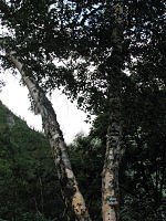 From the Bridge, the last three kilometres to Ghangharia are a steep climb. Birch trees cover the mountain slopes. Mountain paths which don’t seem to be in use are visible across the river.
Helipad for access to Ghangharia, Valley of Flowers and Hemkund
A helipad, a green clearing came into view a kilometre before Ghangharia. Another helipad at Govind Ghat, just below the police check-post is used by Prabhatam Airways to connect Ghangharia and Govind Ghat. The service is new, and we didn’t get any reviews.
We reached Ghangharia at 2.30 p.m. and were surprised to find a mobile phone tower here. Least expecting one at these heights, we had left our cell phones back at Govind Ghat!
Travel guide
Hemkund trek Map
GM:64 By Road
Rishikesh – Govind Ghat: 275 km
Rishikesh – Joshimath: 253 km
Joshimath – Govindghat: 22 km
Trek routes
Govind Ghat – Ghangharia (Govind Dham): 13 km
Ghangharia (Govind Dham) – Hemkund: 6 km
Govind Ghat – Hemkund: 19 km
Govind Ghat – Valley of Flowers: 16 km
Ghangharia (Govind Dham) – Valley of Flowers: 3 km
Trekking Season
The trek route to Valley of Flowers is open from mid June to the first week in October, while the Hemkund route opens just a wee bit earlier, snow-covered even in June.
Hemkund Saheb yatra will close on October 4th, 2008 for this year.
Himalaya Series
- Hill trains of India
- Ganga Arti at Rishikesh
- White water rafting, Shivpuri to Rishikesh
- German bakery at Laxman jhula, Rishikesh
- Srinagar in Garhwal Himalaya
- Trek to Tungnath, Chopta
- Ukhimath in Garhwal Himalaya
- Madmaheshwar, Panch Kedar
- Stopover at Joshimath
- Auli in June
- Valley of Flowers, Garhwal Himalaya
- River Kosi, Jim Corbett National Park
- Buffer zone, Jim Corbett National Park
- Weekend at Jim Corbett National Park
- Hartola, Kumaon Himalaya
- Manali in January
- Weekend in Leh, Ladakh
Palanquin

Invitation to Kak Bhusundi taal